
GNSS Systems Explained
Author: Marcel Weber
GNSS systems are the invisible infrastructure behind modern navigation, logistics, aviation, telecommunications, autonomous mobility, surveying, disaster management and precision positioning worldwide.
From GPS and Galileo to GLONASS, BeiDou, NavIC and QZSS, satellite navigation systems provide essential Positioning, Navigation and Timing services that support billions of devices and critical infrastructure every day.
This guide explains how GNSS systems work, including their architecture, signals, constellation design, frequency bands, accuracy, error sources, augmentation techniques, trilateration and real-world applications.
Key Insight: GNSS is not only a navigation technology. It is a global infrastructure layer that enables transport, telecom networks, autonomous systems, precision agriculture, maritime operations, emergency response and high-accuracy geospatial services.
Abstract
Global Navigation Satellite Systems (GNSS), such as GPS, Galileo, GLONASS, BeiDou, NavIC and QZSS, provide essential Positioning, Navigation and Timing services worldwide. These systems have transformed industries such as transportation, telecommunications, surveying and disaster management, becoming indispensable in modern technology.
While standard GNSS offers meter-level accuracy, advanced techniques such as Real-Time Kinematic and Precise Point Positioning can achieve centimetre-level precision despite challenges such as atmospheric delays, multipath interference and signal disruption.
Augmentation systems such as WAAS, EGNOS and GAGAN further enhance accuracy and integrity, supporting reliability for safety-critical applications. The integration of GNSS with Inertial Navigation Systems also enables robust navigation in challenging environments such as tunnels, urban canyons and signal-denied areas.
Keywords: GNSS, GPS, Galileo, GLONASS, BeiDou, NavIC, RTK, PPP, INS, augmentation systems, positioning, navigation, timing.
Master GNSS Architecture, Signals and Applications
GNSS knowledge is essential for professionals working in satellite navigation, aerospace, autonomous mobility, geospatial intelligence, logistics, telecom infrastructure and precision positioning.
SEAC’s GNSS Systems Course covers GNSS architecture, signals, RTK, PPP, error sources, augmentation systems, INS integration and real-world applications.
Explore the GNSS Systems CourseIntroduction to GNSS Systems
Global Navigation Satellite Systems are satellite constellations that operate across multiple frequency bands to provide positioning, navigation and timing services worldwide. Each GNSS has unique characteristics, constellation designs and signal structures.
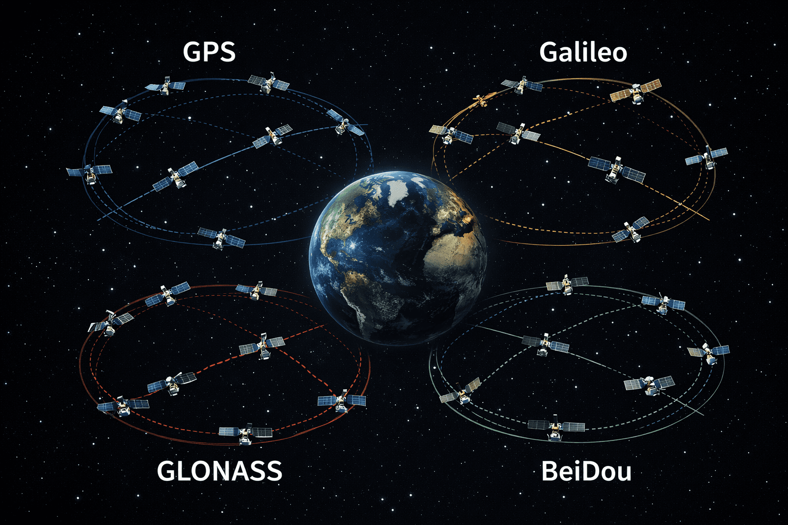
GPS from the United States has led the way for many years and paved the path for other satellite navigation systems. Today, the most important GNSS constellations include GPS, Galileo, GLONASS, BeiDou, NavIC and QZSS, each offering either global or regional coverage.
GNSS technology has revolutionised transportation, telecommunications, surveying, defence, agriculture and disaster management. Modern smartphones, vehicles, maritime systems, aircraft and IoT devices increasingly depend on multi-GNSS positioning for improved availability and accuracy.
Standard GNSS typically provides meter-level accuracy, while advanced techniques such as Real-Time Kinematic and Precise Point Positioning can reach centimetre-level precision. However, accuracy depends on factors such as satellite geometry, atmospheric conditions, multipath interference and receiver quality.
GNSS Systems Architecture
The architecture of a GNSS constellation consists of three main components: the space segment, the control segment and the user segment. These three layers work together to provide reliable positioning and timing services worldwide.

Space Segment in GNSS Systems
The space segment consists of satellites orbiting Earth and transmitting radio signals containing orbital position and precise timing information. Most GNSS satellites operate in Medium Earth Orbit, around 20,000 kilometres above Earth, enabling broad coverage and stable signal geometry.
Control Segment in GNSS Systems
The control segment is the monitoring and management backbone of GNSS. It includes ground stations, control centres and uplink antennas that track satellite orbits, monitor clock performance, calculate corrections and upload navigation data.
User Segment in GNSS Systems
The user segment includes all receivers and applications that process GNSS signals. This ranges from smartphones and vehicle navigation systems to high-precision surveying receivers, aircraft systems, autonomous vehicles and scientific instruments.
Constellation Design in GNSS Systems
GNSS constellation design determines how satellites are arranged in space to provide reliable global or regional coverage. Most global systems use Medium Earth Orbit because it offers a balance between coverage, signal strength, orbital stability and satellite visibility.

Satellite navigation systems may use different orbit types to achieve global or regional coverage, optimise signal strength and improve reliability. These design choices allow GNSS systems to support applications ranging from consumer navigation to high-precision professional positioning.
GNSS Bands

GNSS signals are transmitted in specific frequency bands, each designed for performance, accuracy, compatibility and resistance to interference. These bands are commonly located in the L-band and are shared across systems such as GPS, Galileo, GLONASS and BeiDou with specific variations.
Multi-frequency GNSS receivers can improve performance by comparing signals on different frequencies. This helps correct ionospheric delay and enables advanced positioning techniques such as RTK and PPP.
GNSS Signals
GNSS signals consist of a carrier wave, spreading code and navigation data. The carrier wave is the high-frequency radio signal transmitted by the satellite. It carries timing and navigation information to receivers on Earth.
A spreading code, also known as a pseudorandom noise code, allows receivers to distinguish between satellites, resist interference and measure signal travel time. Navigation data provides satellite orbit, clock and system information required for position calculation.
Spreading codes are usually divided into three main types:
- Coarse/Acquisition Code: A civilian-accessible code used for faster signal acquisition.
- Precision Codes: Longer and often encrypted codes used for higher accuracy and protected applications.
- Modernized Codes: Newer civil signals designed for improved robustness, interoperability and multipath resistance.
Technical Insight: Multi-GNSS and multi-frequency receivers improve positioning performance by using more satellites, stronger geometry and better correction of atmospheric delays.
GNSS Satellite Systems: GPS, Galileo, GLONASS, BeiDou and NavIC
GPS
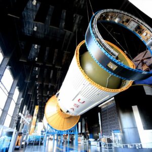
The Global Positioning System, developed and maintained by the United States, is the world’s most widely used satellite navigation system. It consists of satellites in Medium Earth Orbit distributed across multiple orbital planes to ensure global coverage.
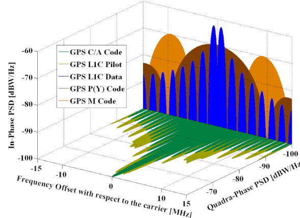
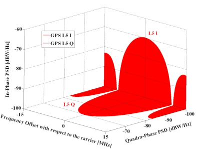
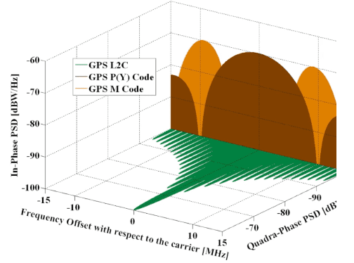
GPS satellites transmit timing and orbital data on multiple frequencies, including L1, L2 and L5. These signals allow receivers to calculate position, velocity and time through trilateration.
- Uses atomic clocks such as caesium and rubidium clocks.
- Supports L1, L2 and L5 frequency bands.
- Provides civilian, commercial, scientific and defence applications.
- Supports integration with other GNSS constellations for improved reliability.
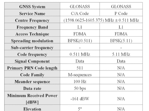
GLONASS
GLONASS is Russia’s global satellite navigation system. It serves as both an alternative and a complement to GPS. The system operates satellites in Medium Earth Orbit and is known for strong performance at higher latitudes.
- Constellation: Around 24 operational satellites.
- Orbit: Medium Earth Orbit at approximately 19,100 kilometres altitude.
- Signals: Historically used FDMA, with modernised satellites supporting CDMA signals.
- Use cases: Navigation, timing, transport, defence and high-latitude positioning.
Galileo
Galileo is the European Union’s global satellite navigation system. It is civilian-controlled and designed for high accuracy, reliability and interoperability with other GNSS constellations.
- Constellation: More than 24 satellites in Medium Earth Orbit.
- Signals: E1, E5 and E6 frequency bands.
- Strength: High civilian accuracy and strong interoperability.
- Applications: Aviation, smart mobility, agriculture, surveying and emergency services.
Galileo is especially important for civilian high-accuracy applications and supports modern multi-GNSS receiver performance when combined with GPS, BeiDou or GLONASS.

BeiDou
BeiDou is China’s global navigation satellite system. It provides positioning, navigation and timing services through a hybrid constellation that includes Medium Earth Orbit, Geostationary Orbit and Inclined Geosynchronous Orbit satellites.
- Constellation: Hybrid architecture with GEO, IGSO and MEO satellites.
- Signals: Includes B1, B2 and B3 frequency bands.
- Unique feature: Short message communication capability in selected services.
- Applications: Transportation, maritime navigation, smart agriculture, logistics and autonomous systems.

NavIC
NavIC, also known as the Indian Regional Navigation Satellite System, is India’s regional satellite navigation system developed by the Indian Space Research Organisation. It provides positioning and timing services over India and surrounding regions.
- Coverage: India and adjacent regions.
- Architecture: Uses GEO and IGSO satellites.
- Frequency bands: Includes L5 and S-band signals.
- Applications: Transport, maritime operations, disaster management, agriculture and defence.

Types of Errors in GNSS Systems

Satellite Clock Errors
Satellite clocks are extremely accurate, but they can still drift over time. Even tiny timing errors can cause positioning errors because GNSS distance measurements are based on signal travel time.
Satellite Orbit Errors
Orbit errors occur when the satellite’s reported position does not perfectly match its real position. Ground control stations monitor satellite orbits and upload corrected ephemeris data to reduce these errors.
Ionospheric Delay
The ionosphere contains charged particles that slow down and bend GNSS signals. Dual-frequency receivers can reduce this error by comparing signals at different frequencies.
Tropospheric Delay
The troposphere contains humidity, water vapour and gases that delay GNSS signals. Tropospheric models and correction algorithms are used to estimate and reduce these effects.
Multipath Errors
Multipath occurs when GNSS signals reflect off buildings, water, terrain or other surfaces before reaching the receiver. This is common in dense urban areas and can reduce positioning accuracy.
Receiver Noise
Receiver hardware, antenna quality and signal processing can introduce additional noise. High-quality receivers and antennas are essential for professional and high-precision applications.
Trilateration in GNSS Systems
Trilateration is the geometric method used by GNSS receivers to determine location. Unlike triangulation, which uses angles, trilateration uses distance measurements from known satellite positions.
The receiver calculates its distance from each satellite by measuring the time delay between signal transmission and reception. Each distance creates a sphere around a satellite. The intersection of multiple spheres allows the receiver to estimate its position.
- Three satellites can provide a basic two-dimensional position.
- Four or more satellites are required for three-dimensional positioning and receiver clock correction.
- More satellites usually improve geometry, reliability and accuracy.
Applications and Compatibility of GNSS Systems
GNSS systems are used across a wide range of industries and critical applications. Their value increases when receivers combine multiple constellations, improving availability and resilience.
- Aviation and maritime: GNSS supports route navigation, safety systems and operational efficiency.
- Telecommunications: Accurate timing supports network synchronization and critical infrastructure.
- Smartphones and IoT: Multi-GNSS receivers improve location performance in consumer devices.
- Autonomous vehicles: High-precision GNSS supports localization, sensor fusion and route planning.
- Precision agriculture: GNSS enables automated machinery, mapping and optimized resource use.
- Surveying and construction: RTK and PPP provide centimetre-level positioning for professional applications.
Differences Between GNSS Systems
Although all GNSS systems provide positioning, navigation and timing services, they differ in constellation design, signal structure, coverage, accuracy, governance and regional strengths.
- GPS: Global coverage and the most widely used system.
- Galileo: High civilian accuracy and strong interoperability.
- GLONASS: Strong performance at high latitudes.
- BeiDou: Hybrid constellation with strong presence in Asia and additional messaging capability.
- NavIC: Regional system focused on India and neighbouring areas.
- QZSS: Regional augmentation and navigation support focused on Japan and Asia-Pacific.
Build Expertise in GNSS Technologies
Understanding GNSS systems is increasingly important for professionals working in aerospace, autonomous mobility, telecommunications, geospatial intelligence, robotics, logistics and satellite infrastructure.
SEAC’s GNSS Systems Course covers satellite navigation architecture, RTK, PPP, signals, augmentation systems, INS integration, error modelling and real-world applications.
Explore the GNSS Systems CourseConclusion
GNSS systems are one of the most important infrastructures of the modern world. They provide positioning, navigation and timing services that support transport, telecom networks, aviation, maritime operations, smartphones, autonomous vehicles, agriculture and scientific applications.
GPS, Galileo, GLONASS, BeiDou, NavIC and QZSS each have different strengths, but the future of satellite navigation lies in interoperability. Multi-GNSS receivers can combine several constellations to improve accuracy, reliability and resilience.
As autonomous mobility, robotics, smart infrastructure and geospatial intelligence continue to grow, GNSS will remain a foundational technology for the digital economy and the future of satellite-based services.
References
GNSS Systems – SEAC Courses: https://seac-space.com/courses/gnss-systems/
GNSS reference material: https://www.princeton.edu/~alaink/Orf467F07/
GPS – Essentials of Satellite Navigation: u-blox GPS Compendium
Frequently Asked Questions About GNSS Systems
What are GNSS systems?
GNSS systems are Global Navigation Satellite Systems that provide positioning, navigation and timing services through satellite constellations. The main systems include GPS, Galileo, GLONASS, BeiDou, NavIC and QZSS, supporting applications from smartphones to aviation and precision agriculture.
What is the difference between GPS and GNSS?
GPS is one specific satellite navigation system operated by the United States, while GNSS refers to all global and regional navigation satellite systems. GNSS includes GPS, Galileo, GLONASS, BeiDou, NavIC and QZSS, allowing receivers to use multiple constellations.
Which GNSS systems provide global coverage?
The main GNSS systems with global coverage are GPS, Galileo, GLONASS and BeiDou. Regional systems such as NavIC and QZSS focus on specific geographic areas but can improve availability and performance when used together with global constellations.
How accurate are GNSS systems?
Standard GNSS positioning typically provides meter-level accuracy, depending on receiver quality, satellite geometry and environmental conditions. Advanced techniques such as Real-Time Kinematic and Precise Point Positioning can deliver centimetre-level precision for professional applications.
What is RTK in GNSS?
RTK, or Real-Time Kinematic positioning, is a high-precision GNSS technique that uses correction data from a reference station or network. It can achieve centimetre-level accuracy and is widely used in surveying, construction, agriculture and autonomous systems.
What is PPP in GNSS?
PPP, or Precise Point Positioning, is a GNSS technique that uses precise satellite orbit and clock corrections to improve positioning accuracy. Unlike RTK, it does not always require a nearby base station, making it useful for wide-area professional positioning.
What causes GNSS errors?
GNSS errors can be caused by satellite clock drift, orbit errors, ionospheric delay, tropospheric delay, multipath interference, poor satellite geometry and receiver noise. Correction techniques, augmentation systems and multi-frequency receivers help reduce these errors.
How does GNSS trilateration work?
GNSS trilateration works by measuring distances from satellites with known orbital positions. The receiver calculates signal travel time from multiple satellites, and the intersection of these distance spheres allows it to estimate position and correct receiver clock error.
Why is multi-GNSS important?
Multi-GNSS is important because using several constellations increases satellite availability, improves geometry and enhances positioning reliability. This is especially valuable in cities, mountains, forests and other challenging environments where some satellite signals may be blocked.
Why is GNSS important for autonomous vehicles?
GNSS is important for autonomous vehicles because it provides positioning, timing and location reference data. When combined with cameras, radar, lidar, maps and inertial sensors, GNSS helps autonomous systems navigate safely and maintain accurate localization.

